
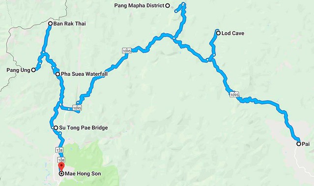
The best way to explore the exotic Northern Thailand’s Mae Hong Son province is by taking a road trip and complete the whole Mae Hong Son Loop.
Mae Hong Son is one of the provinces in Northern Thailand which is bordered by Myanmar to the west. It is also the most mountainous and forested province in Thailand, covered with mist all year round.
As one of the poorest region in Thailand and home to many ethnic hill tribe communities in the surrounding areas, Mae Hong Son is still relatively out of the beaten track if compared to its neighbouring province of Chiang Mai.
Due to its relatively remote location, the province doesn’t really see a huge group of tourists, especially foreign visitors. Nevertheless, there is absolutely no shortage of amazing sceneries in Mae Hong Son.

Mae Hong Son offers little in terms of modern conveniences but a lot in terms of raw natural beauty.
The best way to explore Mae Hong Son is to get on a motorbike and complete the whole Mae Hong Son loop, which is a circular route going in and around the province.
The Mae Hong Son Loop has the perfect scenario for an epic motorbike adventure as you will be driving through the national parks, rolling farmlands, dense jungles, ethnic villages, mist-shrouded mountains, lakes, rivers, caves, thunderous waterfalls, ancient temples, lush rice fields, and beyond-stunning countryside sceneries.
As you ride along this route you will be completely awestruck with the panoramic views that seem to go on and on.

Get off the tourists’ trails and into the hearts of the countryside. The road journey will open your eyes to Thailand’s true rural culture.

There are many hill tribe communities and villages nestled in the mountains. Most of them are still traditional and some rarely see tourists passing through.
About Mae Hong Son Loop – Bends and Straights
This article aims to provide you with the most useful tips on how to make the most out of your epic road journey from start to finish. And I’m all about getting you guys inspired to go on this trip because it’s going to be the trip that changes your outlook on the world and maybe even your life.
The Mae Hong Son Loop, with over 600km of road and more than 4,000 curves, is the most famous route in Thailand among the cyclists and motorists. It has everything a touring motorcyclist could want: bends and straights, great wildlife, beautiful ethnic villages and towns, and amazing views.
It can be done in 3~4 days but is better covered over 7~10 days. The minimum number of places you can stop is three, Pai, Mae Hong Son, and Mae Sariang are standard, but the whole journey is a brilliant ride that will be better enjoyed the more you stop.

The 600km+ Mae Hong Son loop starts in Chiang Mai and passes through the three main towns of Pai, Mae Hong Son, and Mae Sariang.
Mae Hong Son Loop Starts and Finishes in Chiang Mai
Chiang Mai is the starting or ending point for most travellers visiting Northern Thailand. One way or another you’ll end up here. Chiang Mai International Airport (IATA: CNX) is the major gateway to Northern Thailand with more than 20 domestic and international airlines fly into Chiang Mai.
The city is an excellent starting point for your two-wheeled journey. After you’ve taken your time to fully explore their street markets and temples, you should aim to hit the road and let the true adventure begins.

Chiang Mai’s Sunday Walking Street Night Market is the best and unique of its kind. If you get Sunday in your days here then you must not miss this awesome night market.
Rent A Motorbike From Chiang Mai
If you’re planning to DIY your Mae Hong Son loop road trip then the first thing you’ve to do is rent a motorbike. The process is very easy, and cheap. There are many motorbike shops in the city of Chiang Mai. Just walk around the streets in and surrounding the old city moat and you will find them very easily.
If you ride alone without carrying a passenger on the back of the motorbike, a 125cc automatic scooter is good enough for the trip. The rental is usually 200~250 Baht a day. But if you don’t mind paying extra for a little more comfort, or if you have to carry a passenger, take a bigger scooter with the bigger engine (like the 150cc scooter). The rental is usually 500 Baht a day.
There’s also a wide selection of big motorbikes for the ADV enthusiasts. Depending on your preferred model and horsepower, the bike’s rental ranges from 1,000~2,500 Baht per day.

Mr. Mechanic is a popular motorbike rental shop located in the heart of the old city with a good reputation for friendly service and good bikes.

If you arrive at Chiang Mai by bus, there are a few motorbike shops close to Arcade Bus Terminal and they open 24 hours. You can rent a motorbike here and drive it to your hotel.
Most motorbike shops require keeping your passport as the security deposit, or a cash deposit of 3,000 Baht (more or less), which is refundable when you return the motorbike in its original condition. Remember, rent a motorbike is cheap, but to repair it’s expensive.
Make sure the motorbike comes with proper insurance. Some motorbike insurance covers only the riders, but not the damage of the motorbike. Ask them and be sure before you pay.
Even though a driver’s license is not a requirement to rent a motorbike, but be warned that you are driving illegally if you don’t have an international license or a Thai license. Motorcyclist without a valid license could be fined 500 Baht if get pulled over by the police officer at a roadblock.

A police roadblock like this is commonly seen in Chiang Mai. Motorcyclists are usually fined for traffic offenses such as driving without a valid driver’s license or for not wearing a helmet.
Use Google Map As Trip Planner
You can use your mobile phone’s Google Map as the trip planner as it is an excellent navigation app for you to get from town A to B efficiently. All locations mentioned in this article can be found on Google Map.
In order to run the app smoothly, you’ll need a local SIM card in Thailand for your phone to connect to the internet. DTAC, AIS, and TRUEMOVE are the 3 major mobile telecommunication operators in Thailand. Whilst their mobile coverage in towns and on major highways are almost as good as each other, for this Mae Hong Son loop road trip we recommend TRUEMOVE as they work better in properly remote places.
FYI, it is now possible to take Google Map offline. All you need to do is download and save the offline map on your phone, and then you can retrieve the driving directions offline at any time you need it.
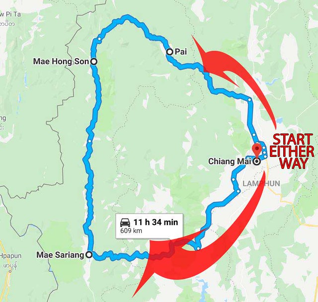
For this road trip, you have a few options. You can do it in a clockwise or counter-clockwise direction. Heading North or South first, the direction doesn’t change anything.
Now Let’s Hit The Road
As its name would suggest, the Mae Hong Son loop is … a loop, i.e a road that circles back to its starting point, which is the city of Chiang Mai. So it doesn’t matter too much from which direction you start your journey.
For this article, we will go from:
Chiang Mai <150km> Pai <110km> Mae Hong Son <160km> Mae Sariang <190km> Chiang Mai
Depending on how much time you have, there are a lot of side trips to take that can see you travel longer distances. This article will suggest some very interesting detours for the wildest and most unusual places to travel in Northern Thailand.

Let’s hit the road. And remember to wear a helmet at all times.
Route 1 – From Chiang Mai to Pai
The route from Chiang Mai to Pai is the shortest of all but it is also the curviest, and the most touristy route because Pai is one of the most popular destinations in Northern Thailand.
The entire route takes roughly 3~4 hours if you ride non stop. To avoid reaching Pai after dark especially for the beginner rider, it’s better that you leave Chiang Mai early in the morning to allow for multiple stops along the way for some food and coffee breaks (plenty of cafes serving local Northern Thailand coffee!), stop for photography here and there, detour to the national park, etc.


From Chiang Mai, head for the road 107. Turn left to road 1095 towards Pai when you hit the junction. You will see a huge overhead sign just before the junction.
The hilly, winding roads have in total 762 curves, winding up and down, side to side. With the majestic views of lush mountainsides cloaked in mist, experienced riders may find the slopes and infinite bends fun and challenging.
The roads are in good condition and there are plenty of nice stops along the way. At some point, you may find yourself riding at a snail’s pace (10~20kmh) across the hairpin curves and into the cloud-kissed hills. It sure isn’t for the beginner riders.
The said 3~4 hours ride to reach Pai is for the fast and experienced rider, while newbies could take as much as five hours. But that is alright. Always ride within your capabilities in a safe and controlled manner. Go slowly, enjoy the beautiful landscapes and get some rest at the amazing viewpoints.

The road going to Pai is in pretty good condition. There’s minimal traffic in most parts, and the scenery is awesome.

The route from Chiang Mai to Pai consists of 762 hilly curves, winding up and down the mountain range separating the two cities.
Detour – Huai Nam Daeng National Park
Huai Nam Daeng National Park is situated roughly 60km before Pai. This is an additional 15km (in and out) side trip going through a narrow winding road. The park is a good place to rest and relax after the long drive from Chiang Mai. It charges an entrance fee of 300 Baht.
Huai Nam Daeng National Park is huge (over 1,252km2). Aside from the sweeping panoramic views of green forests and mountains from Doi Kew Lom viewpoint, the areas also include waterfalls and hot springs, hiking and nature trails.
If you want to spend the night under the sky of a million stars, there is a campsite with the tent and sleeping bag available for rent at 250 Baht. Camp overnight here to experience the breathtaking sunset and sunrise, and see the incredible view of the sea of mist and clouds.

Stay overnight at Doi Kew Lom viewpoint to witness the impressive sunrise and the soft white sea of mist enshrouding entire vast valleys.
Pai – Charming Little Town In The Valley
Pai is the biggest town in the entire Mae Hong Son province, also the most touristy one. It’s extremely popular with the new age travellers especially the backpackers, hippies, adventurers, and the party animals.
Over the years, this little town located in the beautiful flat valley has evolved into a popular destination for international and Thai travellers alike. Some travellers may feel Pai is horribly touristy, but certainly many are loving it especially the first time visitors. Some fell in love with Pai that their short trip extended to a week or longer.

The beautiful countryside setting and the mix of ethnic and international cultures make up the charm of this laid-back town.
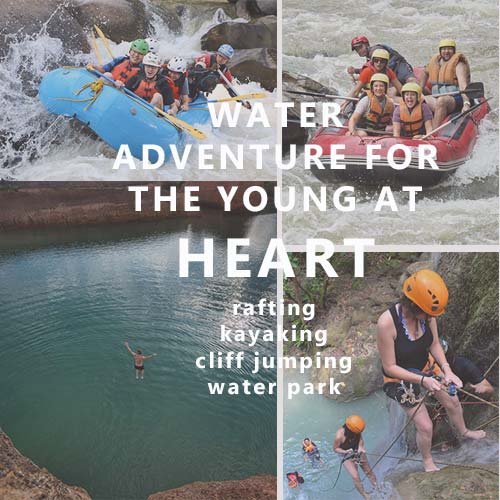
You will need at least 2~3 days to cover the most favourite attractions and fun activities in Pai. You can visit the waterfalls, hot springs, temples, the elephant sanctuaries, explore Pai Canyon, trekking, rafting, or simply spend the lazy day having coffees at the countless cafes throughout the valley.
At night, Pai Walking Street is a great place to walk around. It is a chilling night market with a relaxed atmosphere offering a great variety of Thai foods. Along the way, there are also bars and restaurants hosting live entertainment and have either a band or a singer.

Pai Night Market Walking Street is a great place for food and street shopping. Good to hop from one stall to the other and try their little things.

Pai Canyon is a popular spot for sunset with the great panoramic landscape. Require a little bit of hike to get to the top.

Visit Yun Lai Viewpoint for sunrise and the stunning sea of mist with the background of Pai alley. The entrance fee is 20 Baht.
Route 2 – From Pai to Mae Hong Son (town)
The road leaving Pai is curvy but mostly it’s downhill or flat. If you drive non stop, the route from Pai to Mae Hong Son town is a 2 hours journey (110km).
However, there are some attractions along the way you shouldn’t miss that will add a few more hours to your travelling time, probably to 6 hours in total. You leave Pai in the morning to allow yourself to travel slow and see more.
The journey from Pai to Mae Hong Son town is not far but there are a few side trips worth the detour. Leave Pai early so that you won’t be rushing from one place to the other.
Detour – Phang Mapha District
Roughly 60km to the west of Pai is the Pang Mapha District, a great place for caves exploration, hiking, take a splash at the waterfalls, and having sightseeing in the middle of nature. Caving enthusiasts can go explore Tham Lod Cave and Mae Lana Cave.
If you have time you can stay overnight at the homestays at the Lahu and Shan hill tribe villages. You will learn more about their ethnic cultures and simple lifestyles. Or you may just stop for a short food/coffee break here before continuing with your journey.

Tham Lod Cave is a complex of massive caves with a stream flowing through it. You will be guided and explore the caves on a bamboo raft. The entrance fee is only 100 Baht.

Dekdoi Coffee at Ban Jabo (a homestay). What a great place for coffee and food over the cloud and mist. They serve only noodles.
Detour – Ban Rak Thai
Next, take the detour off the regular loop path to Ban Rak Thai, a beautiful and serene Thai-Chinese village very close to Burma border.
From Pang Mapha, head west on road 1095 for about 45km (takes about 1 hour), you will see a few signage that says Ban Rukthai, with an arrow points to the right (location: 19°25’28.2″N 97°58’48.2″E). Take a right, and follow this narrow road for another 30km (40 minutes) until it ends at the village.

Ban Rak Thai Village is located next to a small, picturesque lake. The sight of old-school China is simply delightful.
Sitting on the shore of a beautiful lake set in a valley surrounded by hills, Ban Rak Thai is a picturesque village with amazing scenery. Here you will see houses built with mudbricks in the traditional Chinese-style.
If you arrive at the village around lunch or dinner time, try their Yunan-style Chinese food at the lakeside views restaurant, which typically includes a lot of tea leaves, pork fat, and oil. Or you can sip a cup of tea at one of the tea houses there offering a variety of homegrown tea leaves, as Ban Rak Thai is also well known for their tea plantations. After that, take a relaxing walk around the tea gardens on the hills surrounding the village where you can learn about growing and processing tea product.
If you want to stay overnight here, there are a few guesthouses operating around the lake. The atmosphere here in the morning is the most perfect where you can watch the mist rising off the lake while sipping a cup of hot coffee from your patio.

You can take a walk right in the tea plantation and immerse yourself amongst all the tea leaves at the hills surrounding Ban Rak Thai.

Cottage type guesthouses – made from mud and influenced by Chinese culture, located right at the middle of hill-side tea plantations.
Pang Ung – The Tranquil Reservoir
A side trip to Ban Rak Thai should be combined with a visit to Pang Ung, a picturesque Shan Minority Tribe Village, about 13km from Ban Rak Thai. Pang Ung is famous for its big reservoir surrounded by pine trees and mountain chains. If you are lucky you may even see some black and white swans swimming in the lake.
The sunrise here is magical with the view of thick solemn mist covering the lake like a weighty woolen blanket, slowly wafted upwards curling gently into the morning air. There is a campsite under the pine trees near to the reservoir – bring your own tent, or rent one from the friendly park rangers.

Pang Ung is tranquil and silently tucked away in the mountains. An ideal place to relax for a few hours, or stay one-night camping at the lakeside.

Take a ride with the bamboo raft around the lake for 150 Baht. If you are here early at sunrise you can glide through the fog and mist floating over the lake surface.
Pha Suea Waterfall
Located around the same area with Pang Ung is the 15 meters (50ft) high Pha Suea Waterfall, which can be visited all year round. It is located inside the Tham Pla Cave-Pha Suea Waterfall National Park.
This medium size waterfall is nestled in a wonderful nature receiving very few tourists. There’re not many things to do here though other than sightseeing, as swimming is not allowed because the currents here can be tricky.
The park’s entry fee is 100 Baht, and you can visit the Tham Pla Cave (the fish cave) as well. It’s a water-filled cave hosting hundreds of blue-back freshwater fishes.

Pha Suea Waterfall consists of six levels and offers some fine walks. It is about 15m high and 30m wide. In the rainy season, the cascading water makes the waterfall look like a rolling mat.
Mae Hong Son Town – The Province’s Capital
Leaving Pang Ung, continue straight via road 1095 for another 45km to arrive at Mae Hong Son town. This little town of just over 6,000 people is the capital of Mae Hong Son province. Unlike Pai, the town is quiet and not swamped with tourists.
Mae Hong Son town is set in a beautiful valley surrounded by high mountains and mostly known for its beautiful scenery, and adventure activities like hiking. The area is also home to a number of ethnically diverse hill tribes communities such as the Shan and Hmong.

Mae Hong Son is a small town nestled in its own lovely valley and surrounded by hills that are often shrouded in early morning mist. Most attractions can easily be reached on foot if you stay in the town center.

Su Tong Pae Bridge (The Bamboo Bridge) is right beside the main highway going to Mae Hong Son town. In the early morning, you can see the local villagers giving alms to Buddhist monks here.
There are some hill tribes villages around the area of Mae Hong Son where you can see the peoples’ daily life in a more natural setting and gain some exotic cultural experiences.
Ban Huai Suea Thao Long Neck Village, a refugee camp for the Karenni (Red Karen) people, is the nearest from Mae Hong Son, of about 10km from town. The largest and the oldest is Huay Pa Keng, on the Pai river close to the Thai-Burma border, about 20km from town and it takes a short boat ride to arrive.
Heading further south for about 40km is the more interesting Hmong Microwave Village. Which is a cozy Hmong tribal village with a beautiful mountain-views agriculture farm.
When visiting their village, you don’t have to feel awkward or afraid because they are used to seeing visitors. Just be polite and feel free to say hi, ask permission before taking a photo, and avoid disrupting their personal spaces. The villagers will be friendly and kind to you.

The people of Ban Huai Suea Thao are used to visitors and are happy to pose for photos, but please ask first. It would be a good gesture to purchase from their shop in return.

Hmong Microwave Village is a small remote village where most of the villagers are farmers. And because the village is located on the top of the hill, the view is amazing.

Visiting the hill tribe villages you’ll get a unique and fascinating look at the simpler way of life of the hill tribe people.
At Mae Hong Son, you can go to Wat Phra That Doi Kong Mu, an ancient Burmese style temple standing on top of Doi Kong Mu hill, with superlative views of the town and the mountainous countryside beyond. It is also a popular viewpoint for sunset.
At night you can visit the Walking Street Night Market which starts at the main road, going through town and around Chong Kham Lake. The atmosphere here is really relaxing, not overcrowded and more family orientated with very entertaining live performances from the locals. It’s a great place for dinner as there are many stalls selling delicious local food at a cheap price as well as a variety of indigenous handicraft, handmade and unique!

Wat Phra That Doi Kong Mu stands high above the town. From here you can see the view of Myanmar mountain range and the Pai Valley.

The Walking Street Night Market has a beautiful setting next to the lake with a great atmosphere. It is like most other markets with food stalls and hand made souvenirs.

The Mae Hong Son Living Museum exhibits insightful information and illustrations about the culture, festivals, food, etc of the town. You can get free brochures and city map here, which is useful for exploring the town yourself.
Route 3 – From Mae Hong Son (town) to Mae Sariang
Unlike the previous drive from Chiang Mai to Mae Hong Son, the next route going to Mae Sariang consist of straight fast roads. The distance from Mae Hong Son town to Mae Sariang is around 160km, and if you drive non stop the entire route takes roughly 3 hours.
This route also has the lightest traffic of all. It’s not as scenic as the roads around Pai, or Mae Hong Son, but is beautiful nevertheless.


The 160km long north-south road from Mae Hong Son to Mae Sariang makes for some excellent and lesser trafficked riding.
Detour – Khun Yuam and Mae Surin
When leaving the Mae Hong Son town, many travellers tend to go straight to Mae Sariang. But if you have time, I would recommend a side trip to Khun Yuam District especially if you are coming in November.
Khun Yuam is a sleepy town located about 70km south of Mae Hong Son, which is exactly the halfway of the journey going to Mae Sariang. The main attractions here are the Mae Surin Waterfall National Park, and Thung Bua Tong wild sunflower field.
The main feature of Mae Surin Waterfall National Park, as the name would suggest, is the 80 meters tall waterfall. You can’t swim here though, but only viewing it from the observation deck across the valley. If you’re really into hiking, the park has an 8km long natural hiking trail BUT the entrance is at the other end of the park, near Mae Hong Son town. (Location: 19°15’17.4″N 97°59’42.6″E)

The 80 meters tall Mae Surin Waterfall seen from the observation deck across the valley.

Mae Surin Waterfall National Park has a beautiful natural hiking trail, which has 17 stations well-marked with signposts explaining the diversified landscape and ecosystems of the trail.
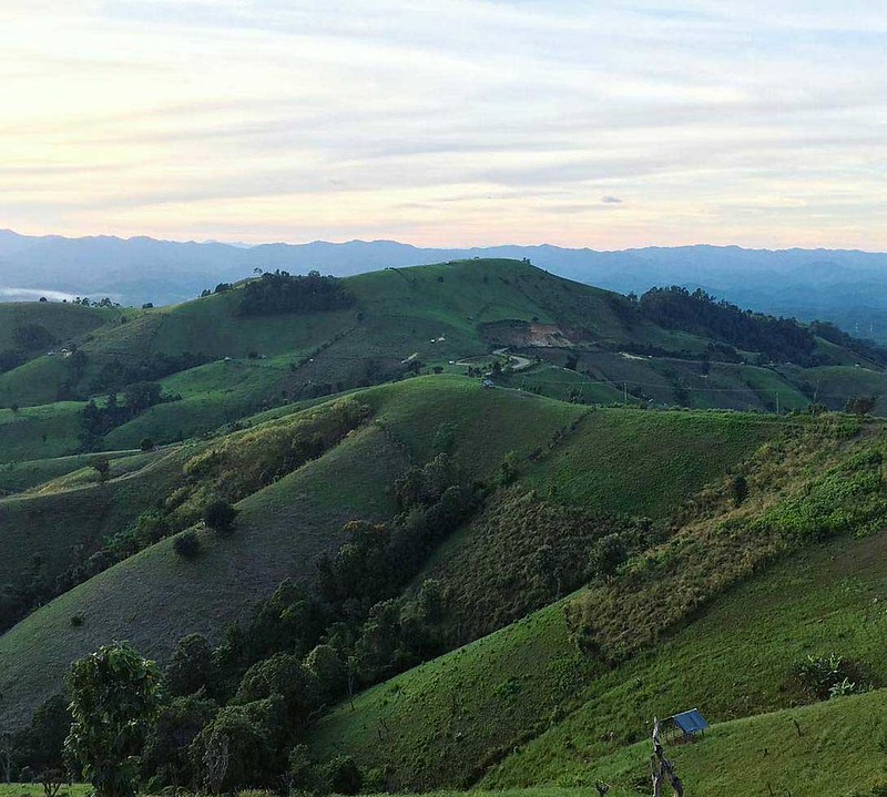
Khum Yuam’s most famous attraction is none other than the Mexican sunflower field i.e Thung Bua Tong Fields at Doi Mae U-Kho. The wild sunflower (in Thai: Bua Tong) blooms only once a year i.e during November ~ December, painting the entire hilly area of Doi Mae U-kho in brilliant gold.
This magnificent sunflower field is located in the same area as Mae Surin Waterfall. When you arrive at Khun Yuam district via highway no.108, shift to road 1263. Keep going for about 40km you will see the sunflower field. Go further for another 15km you will be arriving in Mae Surin Waterfall.

The highly scenic and photogenic Thung Bua Tong Fields is hugely popular with local tourists. The flower only blooms once a year around November to December so plan your trip well.

What a magical natural sights. The Bua Tong sunflowers cover hills after hills at Doi Mae U Kho. Windy road up and down hills but road condition is good.
Mae La Noi
From Khun Yuam, remain on road 108 and continue heading south for about 50km (1-hour ride) you will arrive in Mae La Noi, a very quiet and traditional small town that rarely sees any tourists.
As you approach Mae La Noi (you will see some car repair shops on your left), reduce your speed then turn right into a narrow country road which leads you to the little town’s heart and eventually passing through a panoramic green paddy field.
You can take a short break at the restaurant and coffee shops here before continuing your journey. If you’d like to stay overnight, there is a resort in the middle of the rice field overlooking rice paddies and the mountains.

If you visit Mae La Noi in August or early September, the green and lush field is guaranteed to blow you away!
If you have enough time then you should make a detour to Ban La-Up, a mountain village of the Lawa Hill Tribe. It is located about 25km to the east of Mae La Noi via the narrow winding road no. 1266.
Go further up for another 1km to Wat Phrathat Thammikarat for the incredible 360-degree view you can enjoy from the top. Take in the breathtaking bird’s eyes view of the town, and the magnificent rolling hills especially during sunset.
If you want to wake up to the sea of mist and soak up the beauty of the morning sunrise, there are a few options of homestay in this little village.
The breathtaking views of the rolling hills from the untouched Ban La-Up. The remote location means that most of these villages are still traditional and rarely see tourists passing through.
Mae Sariang – The Untouched Tranquil Town
From Mae La Noi, continue rolling south for another 30km on the road 108, you will arrive at Mae Sariang, a sleepy town that sees very few foreign visitors.
If you prefer something quiet, something isolated and surrounded by beautiful nature, the calm and serene Mae Sariang is the place for you.
There are not many things to do in the town itself. There is a museum, a few temples, pubs, and a night market.

Wat Phrathat Chom Thong. This temple enshrines a huge Buddha statue overlooking the beautiful scenery of Mae Sariang.
Salawin National Park
The most interesting attraction in Mae Sariang is The Salawin National Park which features the Salawin River that forms the boundary between Myanmar and Thailand.
This 2,815km long river is originated from The Himalaya mountain range in Tibet and it flows pass China, Myanmar, and Thailand.
There are 3 gateway to explore the park, namely (1) the national park’s headquarter, (2) Ban Mae Sam Laep, a little village on the riverbank, and (3) Ban Tha Ta Fang, the other small riverbank village.

Salawin National Park is probably the most off the beaten path experience the entire loop has to offer. Very few local tourists, let alone foreign travellers visited the park.

Salawin National Park is very popular with the off-road motorbike enthusiasts because of its magnificent jungle trails that pass through rivers and endless water crossings.
Salawin National Park’s headquarter and visitor center is just 5km west of Mae Sariang town and it is easily accessible via the rural road no.4005. (Location: 18°09’34.2″N 97°53’41.0″E). If you are short on time, here is where you can spend a couple of hours walking around the natural hiking trails.
If you have an extra day in Mae Sariang and prefer a more exotic experience then you must go to Ban Mae Sam Laep, a small hill tribe village sitting on the river bank overlooking the Salawin River and, Myanmar. Ban Mae Sam Laep is about 45km from Mae Sariang via the rural road no.1194. However please don’t take any risk with your small scooter as the road is muddy and unpaved.
You can go with a big dirt bike though, or take a yellow songthaew from Mae Sariang morning market. The fare is 80 Baht one-way plus one baggage (20 Bath extra charge for the second bag). There is no exact time schedule for departure as the car leaves when it’s full so you might want to go there early. If there is no car (or no other passenger) at all, you can charter a private songthaew which costs 1,000 Baht one-way or 1,500 Baht for a round-trip.

Inside the Salawin National Park headquarters and visitor center, there are chalet-style accommodation, as well as a camping site where people can stay overnight.
Ban Mae Sam Laep is a Karen Tribe Village on the banks of the Salawin River, located opposite Myanmar and surrounded by jungle. Here you will find a few rice and noodle shops, grocery stores but hardly any tourists amenities.
You can take a boat trip from the pier to enjoy the beauty of the Salawin River and the natural scenery along the banks. There are 3 routes to choose from. You can cruise south to Sop Moei District (2 hours round-trip at 1,500 Baht per boat seating 10 people), or cruise northward to Ban Tha Ta Fang (40 minutes round-trip at 1,300 Baht, or overnight trip 1,800 Baht).
From Ban Tha Ta Fang, you can take a boat ride across to Myanmar (temporary shelter). It is a 2 hours round-trip ride (1,500 Baht per boat) and you have to make a request from the park officer there first as they’d need to contact the Burmese soldiers there.

The boat pier is the most obvious feature in Ban Mae Sam Laep. At the pier, there are passenger boats, tourists boats, and cargo ships.

The villages along the Salawin River hardly have any tourists amenities. Tourists spend the clear starry night in the tent house.
Detour – Doi Phu Co
If you still have time, take the detour off the regular loop to Doi Phu Co. Distance-wise, the detour is roughly an 80km round trip from Mae Sariang.
Not many tourists have heard of this place, in spite of it being one of the best viewpoints for seeing the 360-degree panoramic sea of cloud in Northern Thailand. It is located 1,406 meters above sea level in the mountain range of Sop Moei District.
From Mae Sariang, head south via road 105 for 25km until you reach the intersection at Sop Moei Village, turn left into the rural road 3004. Continue straight for another 15km until you arrive at the “carpark” area (which is a roadside vacant land). Park your motorbike here and walk up the 1km long hiking trail (30~45 minutes) to the viewpoint. Along the way, you’ll find some hand-painted signages nailed to the trees but they are all in Thai language.

The beautiful viewpoint for seeing the sea of cloud is second to none. With the panorama view, visitors can see both sunrise and sunset here.

From the carpark, visitors must hike up the 1km long trekking path to reach the viewpoint. The hill is very steep. Not recommended for people with weak knees.
There is no accommodation or other tourist facilities at Doi Phu Co. If you want to stay overnight here (for the amazing sunrise and sunset) you have to bring your own tent, food, and water.
Please note that the narrow and windy country road 3004 might be a little tricky for the newbie rider. It is a concrete road with some tight uphill and downhill bends. Some parts of the road are unpaved, and the dusty gravel road gets muddy if it’s raining.
Doi Phu Co – Timelapse
Standing Above The Cloud
Route 4 – From Mae Sariang to Chiang Mai
The route from Mae Sariang to Chiang Mai is 186km long and distance-wise, it is the longest leg of the entire Mae Hong Son Loop. However, it is also the easiest to navigate as you’ll be driving on the two-lane highway for almost half of the trip distance.
If you blast straight through to Chiang Mai the journey takes just a little over 3 hours of driving time. But if you have enough time (1 or 2 nights), I recommend that you take the detour to Mae Chaem District, and to Doi Inthanon National Park, home to the tallest mountain in Thailand.

The journey from Mae Sariang to Chiang Mai is pretty straightforward and easy to navigate. If you have time, visit Doi Inthanon National Park.
The Alternative Route – Khun Yuam to Mae Chaem (Doi Inthanon National Park)
If you only have a short travel time to do the loop, you can take the alternative route to Mae Chaem, from Khun Yuam via the road 1263 and 1088. By going this way, Mae Sariang will be skipped.
Road 1263 and 1088 are tarmac, curvy mountain roads. Not recommended for the small scooter though as these roads are not very smooth. Since they are not connecting the “bigger” towns, you won’t be hitting any traffic on this route. The road feels very remote all the way to Mae Chaem at the foot of Doi Inthanon.

The alternative route, from Khun Yuam to Mae Chaem District. It skips Mae Sariang.
Detour – Doi Inthanon National Park
From Mae Sariang, head west on road 108 (to Hot District) for about 80km where you’ll come to the Mae Chaem intersection (with a big green signage at location: 18°13’21.5″N 98°26’41.7″E), turn left into road 1088 and continue for roughly 40km to the little town of Mae Chaem.
You’ll find some restaurants, temples, shops, petrol station and a 7-11 store along the town’s main street here. A good place for a short coffee break, or to stay overnight at one of the guesthouses for a layover, before continuing with another 30km via road 1192 and 1009 all the way to the top of Doi Inthanon.
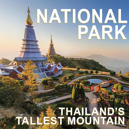
Doi Inthanon National Park is the most popular tourist attraction in Northern Thailand, and home to Thailand’s tallest mountain i.e. Doi Inthanon, standing at 2,565 meters above sea level. Despite the height, it is well maintained and easily accessible by car. Most visitors come to this park on a small day-tour group (by minivan) from Chiang Mai.
There are so many things to do, see and explore in this park that you should stay a night here, or at least arrive early to spend one full day here. Because the park is tropical and mountainous, fog can form very suddenly and then disappear just as quickly. Sometimes the fresh mountain air can be really cold (below 10°C) so be prepared and get a windproof light jacket.

Doi Inthanon is the tallest mountain in Thailand. Standing at 2,565 meters above sea level, it is dubbed The Rooftop of Thailand.
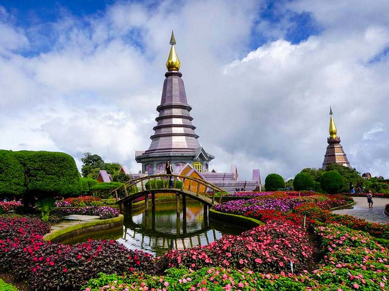
The massive twin chedis surrounded by a beautiful garden is the most iconic structure (and most popular) of the park. Located about 3km before the summit.
If you are an outdoor enthusiast that loves hiking activities, there are 2 hiking trails in Doi Inthanon National Park that you can go i.e the Ang Ka Nature Trail and Kew Mae Pan Nature Trail.
The Ang Ka Nature Trail is sitting at the summit of Doi Inthanon near the viewpoint and carpark. The area could get very busy during peak tourist season (November and December) where there will be food vendors selling noodles, hot coffee, snacks, etc on the roadside. It is opened to visit year round and entry is free.
The trail is a 400 meters long wooden boardwalk infiltrating the dense mossy forest. The place is mostly humid, quiet with sounds of birds, insects, and water. It takes around 30 minutes to complete.

The Ang Ka Natural Trail passes through thick vegetation and canopy of rainforest. Take your camera and enjoy the soft light in natural surroundings.
Compared to Ang Ka Nature Trail, the 2.78km long Kew Mae Pan Nature Trail is more challenging and it takes around 2~3 hours to complete. Please note that it will be closed during the rainy season i.e June to October, and you must hire a guide at a fee of 200 Baht (for a group of visitors not more than 10 people). They are the local Hmong tribe people who will walk with you throughout the trail.
The entrance is located at the big carpark area, about 3km before the summit of Doi Inthanon. The trail is a hilly loop where you will be passing through the rainforest, waterfall, open grassland, hilltops, the magnificent viewpoint, and rivers. The highlight of the trail is the panoramic viewpoint where you can see the stunning views of cloud sea, or the rolling blue-green mountains if the skies are clear.

Kew Mae Pan Nature Trail is a hilly loop where you will be passing through the forest, waterfall, open grassland, hilltops, and back to the forest again.

The panoramic viewpoint at the halfway of Kew Mae Pan Nature Trail. This is where the early risers waiting for the beautiful sunrise.
Chasing Waterfalls at Doi Inthanon National Park
Waterfalls lover can take a splash in the refreshing waters at some of the beautiful waterfalls in the national park. There are eight waterfalls that dive off the mountain. The water flow is good all year round but most impressive during the rainy season i.e May to November.
Mae Klang Waterfall is at the foot of Doi Inthanon and the easiest to get to. It is the most visited among others and can be very busy on the weekend and holidays. The falls cascades nearly 100 meters high over several tiers with the highest tier nearly 25-30 meters tall.
Wachiratan Waterfall is a big waterfall with the falls cascaded and tumbled some 50 meters high. There is a market close to the waterfall where you can buy delicious fresh fruit, candies, dried fruits, various nuts, etc. There are also restaurants and a coffee shop in the area that serve tasty Thai food and drinks at very reasonable prices.

Wachirathan Waterfall is very strong and energetic – lots of thundering water. There is a short trail down to get close to the waterfall for the amazing experience.

Mae Ya Waterfall is the largest waterfall in Thailand, plunging from several tiers over 250 meters.
Mae Ya Waterfall is the biggest and the most beautiful waterfall in the park, with a height of over 250 meters and up to 40 meters wide. The freshwater splashes down over 30 tiers of rocks and boulders into small clear pools. Without a doubt, Mae Ya Waterfall is a photographic favourite for most visitors.
It is located roughly 15km from Chom Thong Village, near the intersection of Highway 108. You can take a detour to Mae Ya Waterfall when you are leaving Doi Inthanon National Park via road 1009, or coming from Chiang Mai if you are doing the loop from the reverse direction.
Mae Pan Waterfall is another supertall waterfall with a height of over 100 meters. It is the highest non-cascading waterfall in the park. Because of its relatively remote location, you will see very few visitors here compared with the other waterfalls.
Coming from Mae Chaem via road 1192, you will pass by the intersection to this waterfall even before you enter the national park area (location: 18°30’46.5″N 98°27’32.4″E). Distance wise, it is 16km from Mae Chaem town.

Mae Pan Waterfall the highest non-cascading waterfall in Doi Inthanon National Park. Due to its relatively remote location, it is not very popular with tourists.
If you want to stay overnight in the park area, there are a few camping options.
There is a campsite situated close to the park’s 1st checkpoint (location: 18°32’31.6″N 98°31’24.7″E). You can rent a tent at 250 baht (good for 3 people) which is inclusive of sleeping bags, pillows and mattresses. The campsite comes with facilities such as bathroom (with hot shower) and power socket to charge your phone. Restaurants and markets for your meal are just within walking distance away.
There is also the more luxurious and spacious type of tent (like a private room) in the same area, called CAMP Inthanon. Daily rental starts from 900 Baht, and you must book online through their official website here. However, they don’t accept payment by credit card. Instead, visitors can only pay via online banking transfer or cash deposit into their bank account (with the slip as proof) to secure booking.
Mae Klang Luang Village – The Living Postcard
Before leaving for Chiang Mai to mark the end of your road trip, make a stopover at Mae Klang Luang, a small Karen tribe village standing amidst hilly rice terraces located just a few kilometers from Doi Inthanon National Park.
In the rainy season i.e August-October, you can see the whole landscape of this little charming village is magnificently covered by the lush rice terraces in descending order. There are cafe and restaurants in the village, where you can just relax and chill out while enjoying the panoramic rice terrace view on the balcony.

The evening views from the rice terraces are spectacular.
Mae Klang Luang
Rice Terraces Amazing Landscape
How Many Days Is Enough For The Road Trip?
As you can see, taking the Mae Hong Son Loop is an incredible way to see the beauty of Northern Thailand as there are so many interesting attractions surrounding the area of the loop. How long does the perfect road trip take all depends on your plan, your travel style, and how much time you have to explore Chiang Mai and Mae Hong Son.
Some finish the loop in 2~3 days. That’s normal for the motorbike enthusiasts who just want to feel the thrill of being on the open road with his/her motorbike. They don’t stop that frequently except for food and rest. They just ride, eat, sleep, … repeat.
Some take more time to complete the trip by travelling at a leisurely pace. They make more stops along the way to break up the long journey for a little extra fun. They stop frequently to take pictures. They enjoyed snacks and smoothies at some of the countless roadside cafés. They try the different activities at the different places of the loop. They are immersed in it. For this type of travellers, anywhere from one week to ten days is usually ideal.

It’s just you, your motorbike and the open road. It is your time to get lost in your thoughts and to enjoy the beautiful road trip.
Take The Mae Hong Son Loop OFF-ROAD – The Dirty Way !!
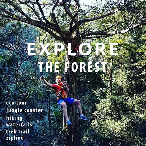
Travelling in Northern Thailand is all about exploring its lofty mountain landscapes, the rustic mountain communities of hill tribe folk, and the lush subtropical countryside.
Modern-day highway network may have connected the major cities and towns, but there’re still many remote, authentic off the beaten path places accessible only by the dense jungle trails with a dirt bike. Especially in Mae Hong Son, known as the most mountainous and forested province of Thailand.
Mae Hong Son still has an astonishing network of unsealed roads. Gravel and dirt trails spread out across the entire province like vines, but generally, remain unknown and untravelled by all but the local farmers, and the wild elephants.
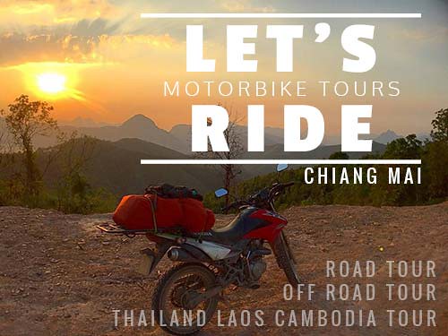
To explore the side of the province seldom experienced by the vast majority of visitors, you should join the dirt bike adventure tour for the off-road version of Mae Hong Son loop, starting from Chiang Mai. We recommend Let’s Ride Motorbike Tour. (See their official website: Let’s Ride)
View this post on Instagram

The off-road motorbike tour allows you to venture into some of the most remote, beautiful and untouched parts of Northern Thailand.
Some Tips and Talking Points About Mae Hong Son Loop:
The beginner motorcycle rider isn’t encouraged to attempt the entire Mae Hong Son loop. The steep winding roads here are trickier and more challenging than what you can imagine – besides, riding long distance is exhausting, mentally and physically.
Try some short touring trips first to build your skill and confidence, like a day trip to Maerim district, or to Doi Suthep National Park. Or you can join the guided motorbike tour where all your comfort, safety, and all the logistics will be taken care of.
Even without a valid driver’s license, you still can rent a motorbike easily and take off on your exciting adventure. But that’d also mean that you’re driving illegally in Thailand. The 500 Baht traffic fine may be cheap (in case of a police roadblock), but what about your travel insurance coverage?
Are you still covered in the event of an accident? Please check your travel insurance’s policy and the motorbike rental company’s insurance. It’s uncool to Gofundme your abroad medical bills when they could’ve been avoided.

The curvy, mountain roads of the Mae Hong Son loop aren’t really the ideal place for motorbike training.

The motorbike day-trip to Maerim District (in Chiang Mai) offers a pretty easy ride for the beginners, with spectacular views too. It’s where the popular Tiger Kingdom is located.
There isn’t really a specifically best (or bad) month to go on the Mae Hong Son Loop even though it’s widely said that the best time to visit Northern Thailand is during the dry and cold season i.e November to February.
But this road trip is also about exploring the hundreds of miles of roads passing through the lush tropical forest, chasing the thunderous waterfalls, and to immerse yourself in the stunning landscapes of the emerald green rice terraces, and all of these will only feature their most amazing colours during the rainy season i.e June to October.

The forests and rice fields appear in their most amazing green colour during the rainy season.
Prepare your trip properly to avoid driving in the dark. Mae Hong Son is a rural province that doesn’t really have proper street lightings on most of its roads. If you drive at night, chances are you’d have to rely on your motorbike’s headlight which could extend only so far in front of your bike.
The poor visibility at night renders it very hard to avoid things such as potholes, road markings, patches of gravel, leaves, etc, especially on bends. It’s extremely dangerous considering that you’re tackling the windy curves of the mountain roads. Watching the sun sets is always a wonderful experience, but don’t take the risk for a long night drive if it’s too far away from your hotel.

Avoid the long overnight drive to the hotel, camping is the best way to experience the breathtaking sunset and sunrise from the mountain top.
Be warned that as you are heading up into the mountain, the temperature could become a little chilly. Stash a wind resistant and waterproof jacket in your backpack especially if you are coming during the cold season i.e November~February. It’s not unusual to see the temperature dropped below 10 Celcius.
Expect to find dense fog in the early morning as well as a wet mist when rolling through the subtropical rainforest.
Mae Hong Son Loop
Over 700km In 7 Days


 – Brochures, Tour Info, Price, Reviews")